

How land use policy doubles as climate policy: Part 2
How land use policy doubles as climate policy: Part 2
How land use planning play a significant role in emissions reduction and climate adapation in our cities.

This is a continuation of my piece on how land use doubles as climate policy. If you haven’t had a chance to read Part 1, where we discussed how land use policy plays a role in reducing transport emissions, you can read it here.
How land use policy can play a role in making a resilient city:
Another issue facing our towns and cities is climate adaptation. The increasing temperature of the planet could result in coastal and low-lying areas inhabitable due to sea level rise, coastal erosion and major rainfall events occurring more regularly in areas built on floodplains and low-lying areas that are prone to flooding.
This has seen discussion in recent years about where we should be building our homes and should existing residents should continue living in these areas with discussion around managed retreats in areas vulnerable to climate change possibly being delivered in a similar model to the managed retreat that occurred on "red zone" suburbs in Ōtautahi following the 2010-2011 earthquakes.
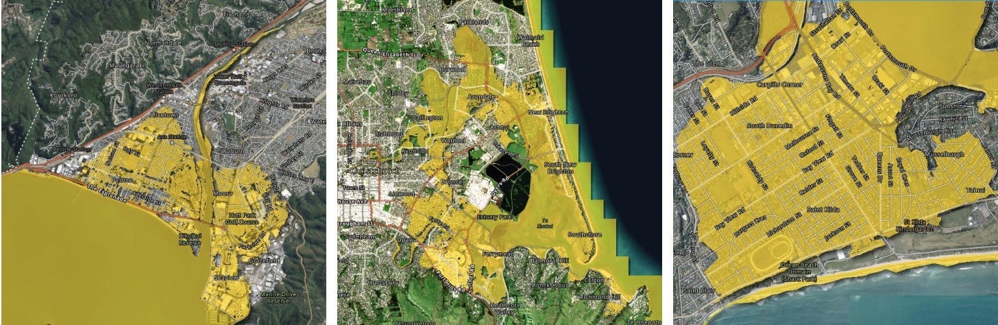
As part of plans for climate adaptation in our urban centres, we need to be smarter about our land use and where we build our infrastructure to avoid major costs to maintain and repair infrastructure following major storm events, mitigate the risk of property damage from natural hazards, which can see properties become expensive to be insured, and in some cases, be unable to be insured and the risk to life.
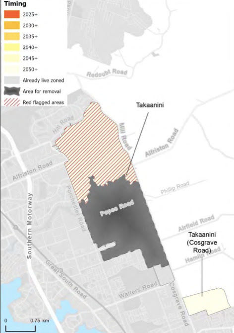
In Tāmaki Makaurau’s Future Development Strategy (FDS) which was adopted late last year. Parts of Kumeū, Huapai, Riverhead, Takaanini, Drury and Hatfields Beach were removed as a future urban area (FUA) following a reassessment of these areas which found the risk from natural hazards such as flooding within 1% annual exceedance probability (AEP) of a floodplain (AEP is a probability of a certain size of flood flow occurring in a single year, with 1% AEP meaning it has a 1% of occurring in any one year), liquefaction and coastal inundation can result in extensive damage to property and infrastructure. Some FUA’s have been “red-flagged”, where development within these FUA’s will need to be managed as it can impose a greater risk of flooding effects within the urban area and need to meet certain requirements to ensure there will be sufficient stormwater infrastructure installed to service the catchment and comply with Healthy Waters Code of Practice.
To accommodate our future growth, alongside those potentially displaced from areas due to managed retreat, while mitigating risk to life and property from natural hazards. We must enable more housing capacity in more resilient areas in our cities.
Following the Auckland Anniversary floods, there were calls to reaccess the implementation of NPS-UD and MDRS in Tāmaki Makaurau, due to concerns about resilience from flooding events.
There are problems with this argument:
Councils have the power to exclude land prone to natural hazards from intensification under the qualifying matters as the management of natural hazards is identified as a matter of national importance under section 6(h) of the Resource Management Act (RMA).
The risk of flooding in built areas in floodplains can be mitigated by investment in stormwater infrastructure and integrating nature-based solutions by daylighting streams, rain gardens, restoring wetlands and greenways such as Te Auaunga Oakley Creek, Freeland Reserve in Roskill South and Maungarei Springs Wetland in Stonefields into the master planning of developments.
The risk to property and life from natural hazards is caused by where we build the homes. While it’s important to consider the resilience of the land before we upzone or rezone it. We need to remember that the typology of the homes built does not decide if properties are at greater risk from flooding and other natural hazards.
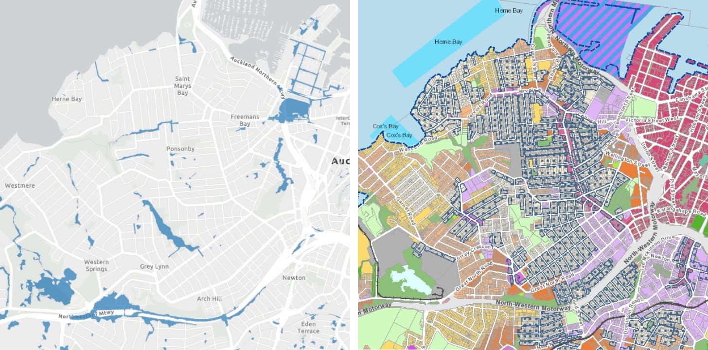
The final point against the argument above is that there are areas in the city that can be upzoned that are more resilient, such as suburbs around the city centre fringe such as Ponsonby, Grey Lynn, Kingsland and Parnell which are less prone to flooding and sea level rise. However, the amount of intensification that has been enabled in these suburbs has been limited due to the special character protections that are in place. Because of the special character protections, these suburbs which are great to intensify due to their proximity to the city centre, walking and cycling distance to amenities, good public transport connections and less prone to natural hazards have been locked from development.
This imposes a significant barrier to creating a more compact and resilient Tāmaki Makaurau. If more housing is not enabled in these areas, development will continue to be pushed out to the peri-urban areas that do not have good access to amenities, public transport and are at a greater risk of natural hazards, it will result in more transport emissions and properties vulnerable to flooding, sea level rise and coastal inundation. This can create poor outcomes for our communities, and make it more difficult to achieve our emission reduction targets in Te Tāruke-a- Tāwhiri and TERP. It can also result in a misalignment with the objectives and policies in the FDS.
Conclusion:
Our land use shapes the outcomes we want as a city. If we want to accommodate our growth while achieving our emission reduction targets and a more resilient city to adapt to our changing climate. We need to design our cities in a form that enables more sustainable living by building more homes closer to where we work, learn, play and shop, along public transport corridors to incentivise mode shift to public transport and active modes. Also, to build our new homes in areas that are less- prone to natural hazards and less vulnerable to the effects of climate change. Ultimately, it will help create more compact, sustainable and resilient cities for the future.