
Creating resilience in a growing city
Planning for growth and adapting to climate change in Tāmaki Makaurau Auckland

This article was originally published in Issue 225 (September 2025) of Planning Quarterly, the quarterly electronic journal of New Zealand Planning Institute (NZPI). This article was written prior to Auckland Council’s release of the draft changes to replace to Plan Change 78 and the Council’s subsequent vote to withdraw this plan change and replace it with Plan Change 120.
In recent years we’ve seen increasing discussions on how to adapt to our changing climate. The rising temperature of our planet has led to sea level rise, coastal erosion, and an increase in the frequency of major storm events arriving at our doorstep. In this article, I explore how we can create a resilient Tāmaki Makaurau while delivering the capacity to build more homes for our existing and future residents.
After the floods
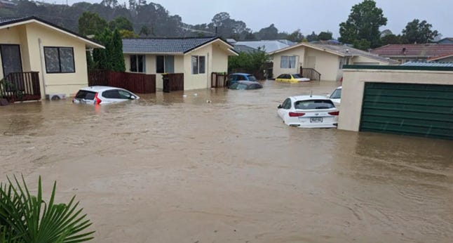
In Tāmaki Makaurau Auckland, the severe weather events during the Auckland Anniversary weekend in January 2023 and the following month with Cyclone Gabrielle have shown the devastation to property, infrastructure and livelihoods that can occur, as thousands of homes throughout the city were damaged from flooding and landslides, with some properties deemed inhabitable1. In the aftermath of these events, discussions began regarding where we should be building our homes and whether existing residents should be residing in areas that are vulnerable to the effects of climate change. However, the population of Tāmaki Makaurau is growing with the city’s population is projected to increase from 1.7 million2 to 2.2 million by 20533. How will the demand to deliver much-needed housing to address the current housing supply and affordability issues be weighed against the realised impact of extreme weather?
The need to be smarter with our land use
The discussion about where people should be building homes has been a national discussion in Aotearoa over the last 10 years. This has come from the risks of sea level rise, coastal erosion and major flooding events which have accelerated more due to climate change. This has opened questions around how communities adapt and where managed retreat will need to be done in existing urban areas and settlements that are the most vulnerable to natural hazards to mitigate the risk to life and property, as seen in Matatā in the Bay of Plenty4 and in “red zoned” areas of Ōtautahi Christchurch following the 2010 - 2011 earthquakes.
This discussion has become a hot topic in Tāmaki Makaurau following the Auckland Anniversary floods in 2023, where four people tragically lost their lives and extensive damage to thousands of properties throughout the city, primarily on the North Shore, West Auckland, and South Auckland. The event caused an estimated $4 billion dollars in damage5. Following the floods, central government and Auckland Council paid $774 million to buy homes of Category 3 properties (Where risk to life is intolerable)6.
In response to the severe events, Auckland Council and central government allocated $760 million to establish “Making Space for Water”: a 10 year programme focused on delivering flood resilience projects throughout the city such as blue-green infrastructure (e.g.: daylighting streams, constructing wetlands), increased maintenance of the stormwater system, improvements to road drainage systems, and public education campaigns to improve awareness for those living in flood-prone areas7. Managed retreat is potentially on the cards with a proposal from Auckland Council to relocate Kumeū town centre following investigations which found there is no viable solution to mitigate the risk of flooding in the town centre8.
Despite this, nearly 3000 homes have been consented in flood prone areas in Tāmaki Makaurau since the Auckland Anniversary floods9. While acknowledging that councils have some limitations in restricting development in flood prone areas, this could result in an unfavourable outcome as the housing we need to deliver for our existing and future residents is being constructed in areas that face a significant risk of property damage from natural hazards. This can see residents face expensive insurance bills, and in some cases, have trouble getting their properties insured at all10. This means we need to be smarter about our land use to mitigate the risk to life and property while at the same increasing housing capacity and achieving other objectives to achieve the city’s emission reduction goals (e.g.: achieving a compact urban form).
What has been done to help create a good outcome
In late 2023, Auckland Council adopted their Future Development Strategy (FDS). The FDS saw the removal of 800 hectares of land in the outer suburbs of Kumeū, Huapai, Riverhead, Takaanini, Drury and Hatfields Beach from being zoned as future urban areas (FUA)11, following findings that the risk from natural hazards can result in extensive damage to property and infrastructure in these areas.
The FDS also saw parts of the city that were zoned FUA areas being “red flagged”. Where any development that occurs within those parts will need to meet requirements to ensure sufficient stormwater infrastructure is installed to service the catchment. The FDS also identified that natural hazards constrain the existing urban areas in the city, so Auckland Council will need to investigate to understand the risks from these hazards and determine the appropriate adaptation responses for these areas.
In June, new provisions added to the Resource Management (Consenting and Other System Changes) Amendment Bill saw the city’s intensification plans as part of the National Policy Statement for Urban Development (NPS -UD) being put back to square one with Plan Change 78: Auckland Council’s proposed intensification plan change to be withdrawn. These provisions will allow Auckland Council to “downzone” areas of the city that are highly vulnerable to natural hazards12. This will likely happen as part of the upcoming intensification plan change to replace Plan Change 78, which Auckland Council must notify to the Minister before 10th October. It’s understood that Auckland Council will notify a natural hazards plan change at the same time, which will update and introduce new natural hazards overlays on the Auckland Unitary Plan (AUP).
The Government will also allow for higher density developments to be enabled up to 15 stories around Maungawhau, Kingsland and Morningside train stations and 10 stories around Mount Albert and Baldwin Ave stations13. These changes not only unlock opportunities for transit- oriented development and maximise the benefits to the City Rail Link (CRL). It will also create additional housing capacity in more resilient parts of Tāmaki Makaurau.
A condition of Auckland Council withdrawing Plan Change 78 from the government is that the replacement intensification plan change must at least deliver the same level of housing capacity as Plan Change 78. With parts throughout Tāmaki Makaurau having reduced housing capacity because of the introduction of the new overlays and the downzoning of areas that are highly vulnerable to natural hazards and the potential managed retreat of existing urban areas and settlements. It creates one big question: Where does the housing capacity go to accommodate our future growth and residents that could be displaced?
There are areas throughout Tāmaki Makaurau that have a higher degree of resilience to natural hazards and have sufficient infrastructure capacity to enable more housing.
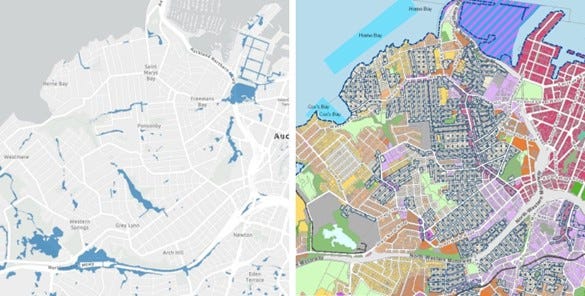
The best existing urban areas to allow this are the inner western suburbs of Freemans Bay, Herne Bay, Ponsonby, and Grey Lynn. These suburbs are less vulnerable to natural hazards, with risk from flooding and sea level rise being low. These areas are well- serviced by frequent public transport routes, amenities and within good proximity to the city centre, aligning with the strategic objectives and policies of Auckland Council’s plans such as Te Tāruke - ā - Tawhiri: the council’s emissions reduction plan14.
However, the housing capacity currently enabled in these suburbs under the AUP has been limited due to the special character area (SCA) overlays placed over most of these suburbs, with a slight reduction of the SCAs on these suburbs proposed in Plan Change 78. Auckland Council’s reasoning for the inclusion of the SCAs in Plan Change 78 is they identified SCA’s as a qualifying matter, citing historic heritage matters15.
SCAs also have an impact on the housing capacity that has been enabled in Remuera, which is less prone to flooding and sea level rise but also well-serviced by amenities and public transport. The housing capacity of the suburb has been limited by the viewshafts from Maungawhau Mt Eden, Maungakiekie One Tree Hill and Ohinerau Mount Hobson. Meadowbank is another suburb that is less prone to natural hazards and, like Remuera, is a prime location to maximise the benefits of the CRL by enabling higher-density development within the catchment of Meadowbank Station. However, most of the walking catchment within Meadowbank Station are zoned Mixed Housing Urban or Suburban under the AUP, which only enables development up to three stories and three homes per site.
This raises a question about whether Auckland Council will consider removing the limitations on building new housing in these suburbs to compensate for the loss of housing capacity, if other areas are downzoned due to the high risk to life and property from natural hazards?
If we want to achieve the good land use outcomes we desire for Tāmaki Makaurau we need to build our homes in the right places, not only in areas rich in amenities and transport choices to achieve our emission reduction targets, but also in areas most resilient to our changing climate. However, we will experience considerable difficulty achieving this if restrictive planning controls, such as SCAs and viewshafts, continue to restrict development in the best places in our city from a hazard resilience perspective. While there are discussions between central government and Auckland Council in reviewing the viewshaft rules to help open more development opportunities16, Auckland Council has a strict deadline to meet for their new intensification plan change to be notified. This means there is a window of opportunity for them to enable more housing capacity in these areas by reducing the amount of SCAs, to remove or amend the viewshaft controls and upzoning to enable higher density developments that can also deliver other major benefits to the city (e.g.: mode shift to public transport).
If these barriers are not removed, it could result in our future development being built in areas that will require extensive investment in stormwater infrastructure to mitigate the severity of the major flooding events such as Henderson and Māngere. These suburbs suffered significant damage during the Auckland Anniversary floods and are currently zoned for medium-density housing in the AUP. It can also encourage development in peri-urban areas that were previously identified as “red-flagged” in the FDS, resulting in significant costs for developers and Auckland Council to build and maintain infrastructure to mitigate the risk from natural hazards, with these costs eventually being passed onto end users, residents and ratepayers. This can result in poor outcomes for many communities and could be seen as counterproductive to the workstreams currently underway by multiple agencies to create a more resilient Tāmaki Makaurau.
Conclusion
How our cities are formed play a significant role in achieving the outcomes we want for our cities. If we are going to create a more resilient Tāmaki Makaurau against natural hazards, as climate change increases the risk these hazards pose to life, property, and infrastructure, we need to ensure that we are building our homes to accommodate our future growth. Also, for potential residents who may be displaced if the danger from natural hazards in existing urban areas is too high. This can be achieved by increasing the housing supply in the most resilient areas of the city.
There is tension between preserving protections like SCA’s and enabling housing in areas that are the most resilient to natural hazards. However, if we don’t remove the barriers that are preventing housing from being built in these areas, the greater the risk is in continuing to deliver unfavourable outcomes for the city. Not only in terms of climate adaptation and urban form but also in not achieving our targets to increasing housing supply, improving housing affordability, reducing emissions, and achieving the objectives and policies in plans and strategies developed by local and central government agencies.
It’s very important to achieve the goals of creating a more resilient city as Tāmaki Makaurau experiences increased frequency of extreme weather events occurring and the effects of climate change on every resident’s doorstep. Tāmaki Makaurau needs to increase housing capacity and supply for existing and future residents whilst improving affordability but as planners we need to pull the biggest levers to building more homes in the right places.
References:
Hundreds of new builds in Auckland flood zones as councils wait on planning reform | RNZ News
Awatarariki Managed Retreat Programme | Whakatāne District Council
Cost of flooding and cyclone events could hit $4 billion - OurAuckland
Auckland Council proposes to move Kumeū due to flood risk, community leaders onboard | RNZ News
Hundreds of new builds in Auckland flood zones as councils wait on planning reform | RNZ News
Auckland and Christchurch’s intensification plans have been reset
Going for growth around the City Rail Link | Beehive.govt.nz
Disclaimer: The views and opinions expressed in this article are my personal views.