


The transformation of neighbourhoods in the heart of the city
A deeper look into the progress of the urban regeneration in Britomart and Wynyard Quarter.

Earlier this week, I had a look at the progress of the urban regeneration occurring in the Britomart Precinct and Wynyard Quarter using a tool many of you are familiar with called Google Street View.
These neighbourhoods located in the beating heart in Tāmaki Makaurau Auckland have received significant public and private investment over the last 20 years to add new life to neglected and under-utilized areas of the city centre to become destinations to live, work, shop, play and celebrate. Today, we’ll be taking a deeper look into the progress so far in those neighbourhoods and also, have a look at what developments and public realm projects are on the way to continue transforming these neighbourhoods.
We’ll start with Britomart, which name comes from Point Britomart, the name given to the area by colonial settlers after the land was gifted to Governor Hobson from Ngati Whātua in the 1840s. In the late 19th and 20th centuries, the area was one of the major business districts in Tāmaki Makaurau, home to many offices and warehouses. However, the buildings in the area experienced a major decline in the later 20th century with buildings empty and neglected and was home to a bus depot and car park building.
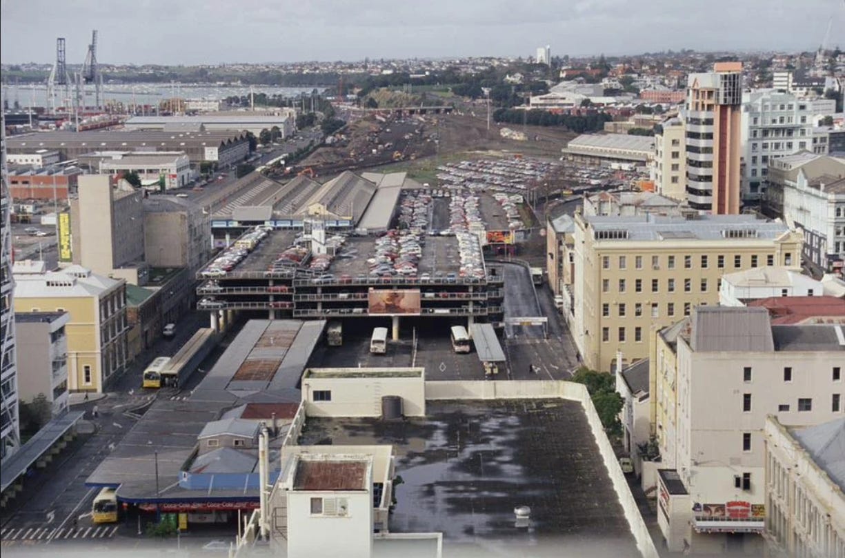
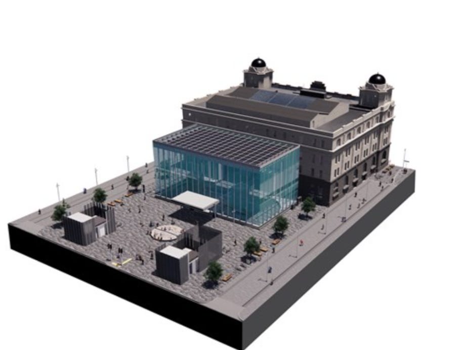
At the turn of the new millennium, the bus depot was closed. It was replaced by the Britomart Transport Centre, which was completed in 2003 and consisted of an underground train station, now known as Waitematā Station. During this time, The Britomart Masterplan was developed to transform the surrounding area into a major retail and hospitality space with laneways and public plazas. The heritage buildings around the station were marked for demolition, but they were kept.
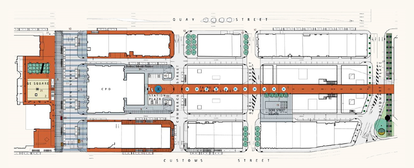
From the mid-2000s, several heritage buildings were refurbished alongside the addition of new low and mid-rise buildings to the precinct with new eateries, retail and offices. New laneways were completed including Te Ara Tahuhu which connects Waitematā Station and a public square at the eastern end of the laneway called Takukai Square, where you can watch the trains leaving the platforms of Waitematā Station through the skylights, have lunch on a sunny day or visiting the local farmers’ markets on a Saturday morning.


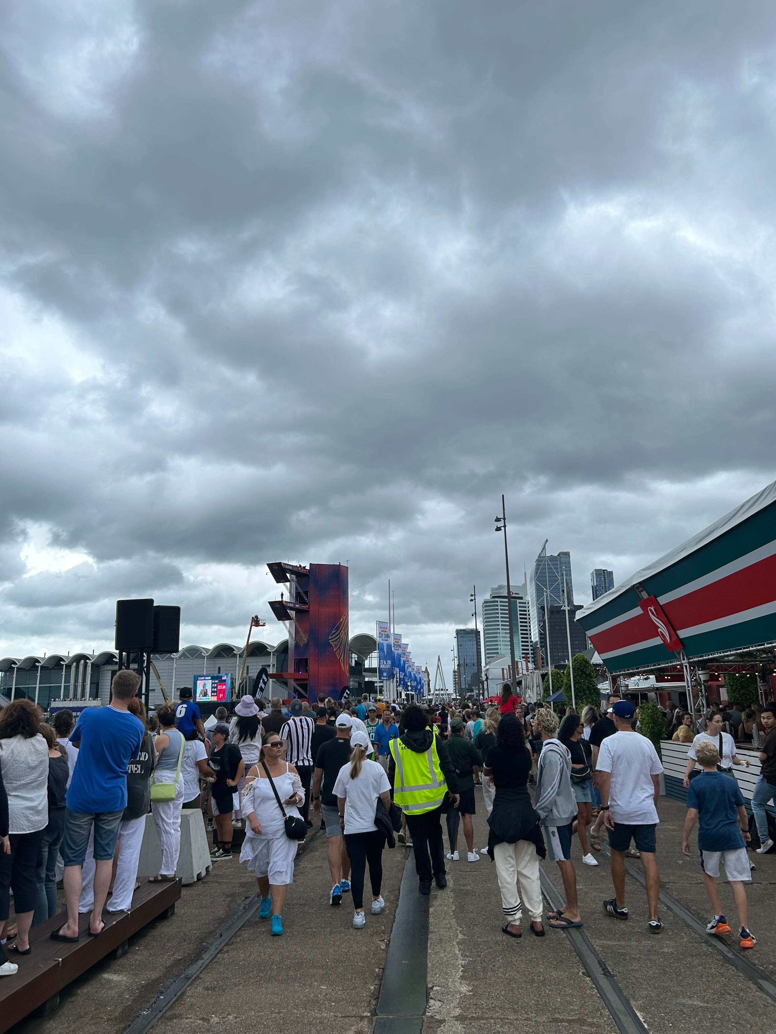
The transformation continued with a hotel, and supermarket opening and street art from local artists. Changes also were made to the street layouts during the construction of the City Rail Link which saw buses moved off Galway St and the streets converted into shared spaces, These changes prioritise the movements of people over cars and opened spaces for outdoor dining for cafes, restaurants and new plants to add some greenery.


Further changes are the return of the plaza on the eastern entrance of Waitematā Station following the demolition of the temporary entrance to the station during the refurbishment of the Chief Post Office, completed in 2022. Upgrades will be made to Tyler St for a shared space, creating a network of shared spaces in the precient. Construction of both of these will begin in April this year with the works to be completed in 2025.
We now head along the waterfront and over the Wynyard Crossing Bridge to Wynyard Quarter.
The land that’s now home to the neighbourhood was not always here as the land was reclaimed by the Auckland Harbour Board (later known as the Ports of Auckland) for berthage capacity for port-related activities. Following fully reclaiming the land in the 1930s, the area was primarily used for timber trade and later as bulk storage for fuel, which gave the area (formally known as the Western Reclamation) the nickname of Tank Farm.
In the mid-2000s, the port did not require the amount of bulk storage that was located on the site and the land was transferred to the Auckland Regional Council. Following that, an agency was established to develop the vision for Wynyard Quarter. The agency became part of Eke Panuku in the supercity merger into Auckland Council in 2010.
In 2011, all sights were on Tāmaki Makaurau and Aotearoa for the Rugby World Cup and just before the major sporting event, the first stage of the redevelopment was completed with public spaces opening along the waterfront. One of these spaces is Silo Park, a green space and playground for families to come together as regular hosts of events (eg: cinema events). The park has kept elements of its industrial past with several silos retained with a gantry where you can go up to check out stunning views of the city.


Between Slio Park and The Wynyard Crossing Bridge is North Wharf, which is home to bars and restaurants with views of the waterfront, which is a pedestrianised link to Slio Park and a gathering place for activations held at the weekends during the summer periods.
More of the area was developed over the 2010s, turning Wynyard Quarter into a mixed-use precinct.
Large mid-size office buildings were built, attracting large employers to the area. Apartment buildings for those to call the neighbourhood home and 2 hotels were built in the area as well. Cafes, restaurants and supermarkets are located on the ground floor of these developments to grab your morning coffee or find your new favourite lunch spot.
Laneways and shared paths were built to improve walking and cycling connections within the neighbourhood. New green spaces were added with a linear park along Daldy St and Amey Daldy Park, adding greenery and more spaces for workers and residents to enjoy.


Developments that are currently under construction in Wynyard Quarter are:
Wynyard Quayside: A series of office buildings on Halsey and Pakenham St. The development is expected to be completed in 2025.
Northbrook Wynyard Quarter: A luxury retirement village consisting of 150 apartments and 40 care units.
A mid-rise office building from commercial developer Mansons on Gaunt St bordered by Beaumont and Daldy St.
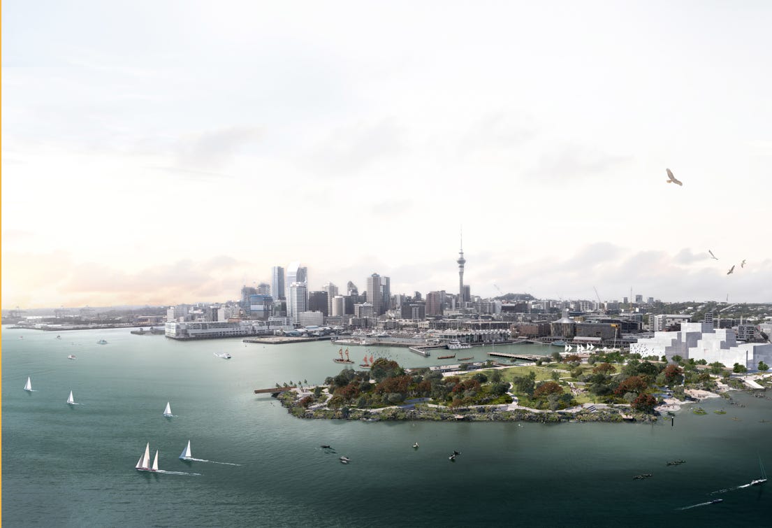
Plans to deliver a large green space over the next 15 years on Wynyard Point called Te Ara Tukutuku, as envisioned in the City Centre Masterplan. The open space will see this part of Wynyard Quarter become a flagship destination for events, a space for people to connect with nature and Te Waitematā with paths and seating areas along the waterfront. The park will see the final piece to the puzzle of the green links formed in the neighbourhood, increasing tree canopy, and biodiversity and reducing stormwater runoff.
It’s great to see the hard mahi involved in turning these neighbourhoods into much-loved spaces and it will be great to see the remaining pieces of the puzzle coming to life to complete the transformation of these neighbourhoods.
What a wonderful article! A great reminder of how far the city has come. I always used to think Auckland was just a collection of tedious suburbs with a rather shabby shanty town at its heart. We have much to be grateful for the visionary Eke Panuku staff and the politicians who championed these changes.
Being a pedantic old grouch have a slight quibble with the term “laneway”, which I think originated in urbanist Melbourne circles. Let’s just call it a lane. A “laneway” Is a lane with a man-bun and a Twitter account.
Terrific overview, Shaun. As an occasional visitor from Dunedin (and keen street photographer), I have followed these changes over the years. Reflecting on developments that have improved the city encourages us to be optimistic about how further changes, in the centre and elsewhere, can increase the liveability and sustainability of Auckland and other cities.